Saturday, March 27, 2010

The Final Stretch - New Zealand

After Milford and Doubtful Sounds we started to head down the Southern Scenic Route of the South Island for our last bit in New Zealand. The first place we wanted to make sure we hit was Bluff to sample the famous Bluff Oysters.


Bluff oysters are only dredged in the Foveaux Strait from March to August and we happened to be there right in season. The Bluff oysters lived up to the hype of being fat and delicate. The only disappointing thing is that they are not served after being freshly cracked open on the half shell. We bought them fresh from the source, however, which made them about half the cost of getting them at a restaurant!


After Bluff we headed to the Catlins area. Here there is beautiful coastline with dramatic cliffs dropping into the ocean. We stopped at Nugget Point where there is an old lighthouse that was built in 1869. Also we spotted a bunch of seals down at the bottom of the cliffs.


After driving the Southern Scenic Route all the way to Dunedin, we went back to Queenstown. We had a few days so decided to head up to Glenorchy to walk a little of the Routeburn Track which is another one of New Zealand's Great Walks. We camped at one of the Department of Conservation sites and had a really fun night with some people we met there. Marisa from San Francisco and Stephan and Sabine from Germany.

We all decided to make the walk together the next morning on the Routeburn. The Routeburn follows a beautiful river and has more amazing waterfalls. If you haven't figured it out by now, if you're a fan of waterfalls New Zealand is your place.


We hiked all the way above treeline to the Routeburn falls. Once above the falls in the valley, the weather got rough with wind and rain, so we headed back down.


The short trek was a great way to wrap up the New Zealand trip. We loved the hiking that we did around New Zealand, and wish we could have done even more of the Great Walks. We were sad to leave New Zealand but excited to head to Australia for a short trip and then to Southeast Asia.


Read more...

Friday, March 19, 2010

Kayaking the Doubtful Sound

Doubtful Sound is not quite as well known as its northern neighbor Milford Sound, but it is quickly gaining prestige and rightfully so. Larger and more remote than Milford, Doubtful Sound is only accessible by guided tour. We opted to go the more low-key route and kayak rather than do a cruise. Doubtful Sound got its name when famed explorer James Cook opted not to sail into the sound because he viewed it as doubtful that he would be able to sail out again.


In the town of Manapouri, just south of Te Anau, we met up with our guides at Adventure Kayaks and hopped in a boat across Lake Manapouri. We arrived at the end of the West Arm of the lake, the site of the Manapouri Power Station, about 45 minutes later. The Manapouri Power Station is interesting itself in that its design and construction were the result of the Save Manapouri Campaign environmental protests against the raising of lake levels of the originally planned station. These protests unified New Zealanders and gave birth to the country's modern environmental movement. The power station is largely underground and takes water from the lake and feeds it through massive tunnels to its release at Deep Cove in Doubtful Sound. This allows the plant to provide energy with minimal disruption to the environment (although, of course, there is some impact).


After a bus ride over Wilmot pass (the few vehicles on this side of the lake are sent over on barges as no roads access Doubtful) we too arrived at Deep Cove. Our luck with the infamous Fiordland weather finally gave out and we climbed in our kayaks in a light but persistent rain. Many of the guides say the misty rain is the best way to see Fiordland. I don't buy it, but I must say it was beautifully atmospheric and didn't detract from the day on the water.


Deep Cove is just one of many arms of the huge Doubtful Sound. We paddled out of Deep Cove and down Hall Arm considered to be the most dramatic of the sound's arms. We would have a total of about five hours of paddling time that day and it really did fly by. Leslie and I shared a double kayak and had a lot of fun paddling together. The water is incredibly calm and the area receives so much rain that the top few meters of water is virtually devoid of salt. This fresh water at the surface also gives the sound a black as oil look which adds the atmosphere of the place.


There are of course the strikingly steep walls, the rainforest flora clinging to the sheer cliffs and the myriad of waterfalls, but the real treat of Doubtful is its isolation. With no roads to access it and a limit to the number of guides, you feel like you're in a lost world, totally alone.


We had a small group, but all were strong paddlers and we moved well and saw a lot of Hall Arm. Unfortunately our camera is not waterproof so we didn't chance it to take many pictures.


There is quite a bit of wildlife in the area (bottlenose dolphins, fur seals, penguins and several species of whale frequent the Sound) but its sheer size means you're lucky to see much and we weren't that lucky.


Doubtful Sound was a nice contrast to the crowds of Milford, equally as beautiful and much more wild. If you go to New Zealand and don't go to Doubtful (and don't kayak for that matter), you're missing out!


Read more...

Monday, March 15, 2010

The Milford Track

"The finest walk in the world"

This quote from an article in the London Spectator by poet Blanche Baughan had perhaps the most significant impact on New Zealand tourism from its 1908 publication date until 2001. We're not sure we would put it at the very top our list, but it is certainly in the running!


It takes four relatively easy days to hike the track from the northern shores of Lake Te Anau to Sandfly Point on the Milford Sound with three nights in New Zealand Department of Conservation huts along the way. It covers a total of about 54 km or 33 miles and reaches its highest point at Mackinnon Pass at 1,140 m (3,740 ft).

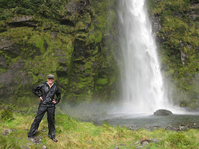
We were very lucky that we had great weather for the full trip. It was cloudy at times but never really rained. Some say the Track's beauty is augmented by the rain in that hard rain makes for more numerous and more intense waterfalls. But we were glad to have the sun!


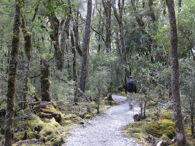
The trip begins from Te Anau Downs which is basically just a parking lot and a dock for the catamaran ferry. The ferry takes you north on Lake Te Anau to Glade Wharf. We caught the later of the two ferries and our boat was filled mostly with "guided walkers." Milford track is one of New Zealand's "Great Walks" and one of the few that has separate huts for guided walkers. These "huts" are more like hotels and, for a hefty fee, you can stay in them and have your own room, showers, meals, etc. Plus you don't have to carry much more than a daypack. The huts on the Milford Track are staggered and the first hut you reach is very close to Glade Wharf where the ferry dropped us off. This is called Glade House and is a guided walkers hut. The nice thing about the huts being staggered is that despite a large number of people of the Track, the separate locations of the huts means we never saw any guided walkers again and enjoyed relatively uncrowded trails. We continued past Glade House for less than an hour to Clinton Hut for the night.


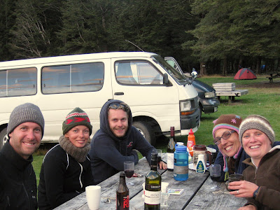
The Track requires all "trampers" to stay in the huts so we needed reservations. We got ours over nine months earlier and were lucky to get them then. An interesting result of this is that you are with the same 40 people in the huts all three nights. On the first night we ate dinner and talked with Darrel and Michelle Lamb. When they found that Australia was our next destination and that we intended to go to Byron Bay over Easter, we learned that Byron Bay is their hometown and that the annual Bluesfest would be happening that weekend. The Lambs are a great example of Kiwi and Aussie hospitality as they offered to let us park our campervan at their house in Byron Bay! More on this and the Lambs in our Australia post coming soon!


That night the hut ranger, Peter, took those interested out for a short walk after dark to see some glow worms and then to observe the stars. We had a perfectly clear night and Peter had a cool laser pointer that literally seemed to reach the stars... and we finally figured out some of the constellations we had been wondering about such as the Southern Cross.

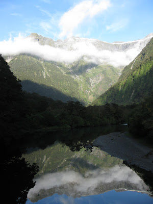
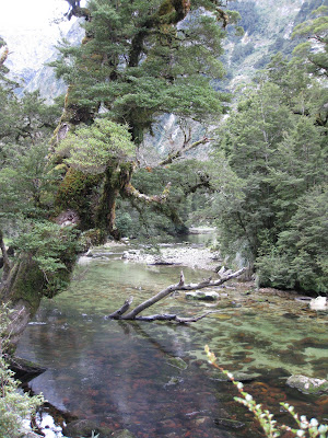
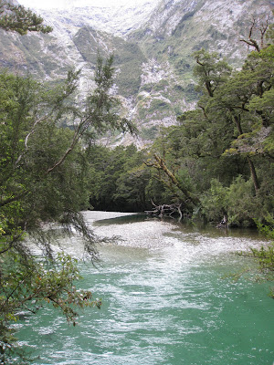
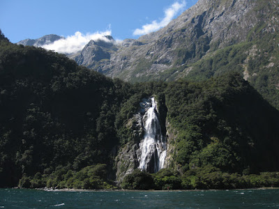
The next day we hit the trail relatively early for a gradual climb along the Clinton River through beautiful forests. The rivers in this area are stunningly crystal clear and an emerald color. We could observe rainbow trout and eels clearly as we hiked along the Clinton. Of course waterfalls are a highlight of the Fiordland area and we saw many this day. But the best was yet to come. We arrived at Mintauro Hut in the early afternoon. The sandflies we have mentioned in earlier posts were out in force making us glad to have the shelter of the hut.


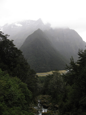
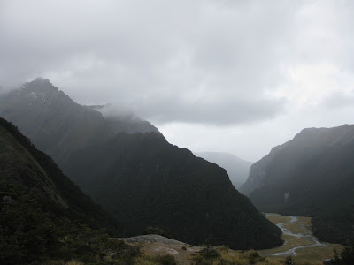
The next day is the biggest by most reports. We again were among the first to set out and headed up steadily right from the hut to the Mackinnon Pass, the high point for the Track. It wasn't totally clear at the pass, but we could still clearly see the Clinton valley we had just traversed and the valley ahead of us.


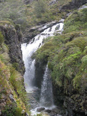
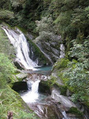
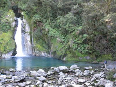
A few kilometers down the trail begins to follow a river. A ways down, back below treeline, the river begins to sharply descend via a series of incredible waterfalls carved into the limestone. This is, for me, the most beautiful part of the Track though it should be mentioned that it is hardly what we would call "wild." While it is understandable due to the remoteness of the location and volume of visitors, it was still a bit disappointing to find steel and wood staircases along the trail. But this is a minor gripe.


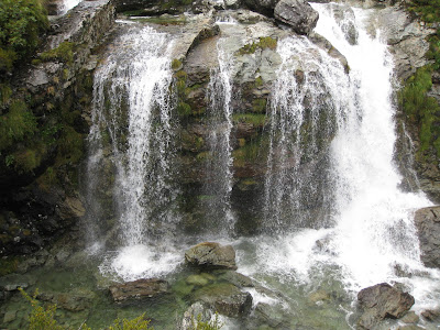
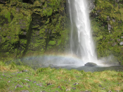
We arrived at the Quintin Public Shelter beside the palatial guided walkers "hut" for an early lunch. From there we did the side trip up to Sutherland Falls. This waterfall is officially New Zealand's highest falls and at one time was believed to be the highest in the world. A nice feature of the falls is that you can literally walk behind them. We tried this and though we got VERY wet, it was well worth it to look up at the falls from behind with the sound of the rushing water reverberating in your chest.


We arrived at Dumpling Hut in early afternoon and again hid from the sandflies in the hut. Though we did take advantage of the seclusion of being among the first to arrive to take a swim in the river.

The final day is the longest in terms of mileage (meterage?), but is pretty easy hiking. This day was by far our best weather bringing clear blue skies with just a few puffy white clouds floating in and out of the valleys. The trail again passes through rainforest and along picturesque rivers and streams boasting waterfalls each uniquely beautiful.


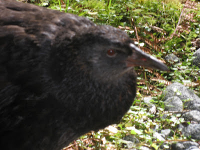
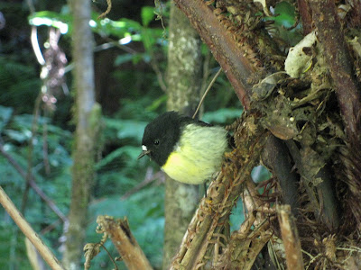
Knowing we were going to have plenty of time to get to Sandfly Point in time for our boat across Milford Sound, we moved leisurely and checked out the myriad of birds in the area. Many of the species have no natural predators so are not very shy. Though a notable exception to this are the introduced animals such as stoats and possums that are currently preying of endangered species such as the Blue Duck and the Kiwi. Still we spotted kea, wekas, robins, bellbirds, tui, fantails, paradise ducks, herons, spoonbill, amongst others.


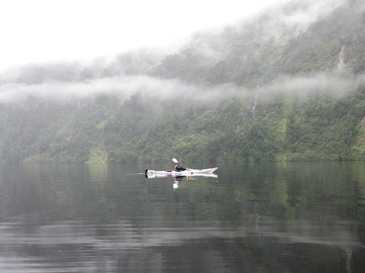
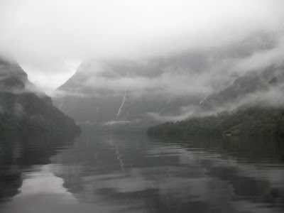
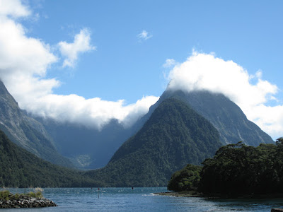
We found Sandfly Point to be, unfortunately, accurately named. Still, we took the time to walk around the area and see some of the stunning vistas the Milford Sound has to offer. We eventually climbed on the boat and headed across the Sound to the Milford Sound Visitor Center. From there a two hour bus ride along the also stunning Milford Road brought us back to Sly, our campervan, in Te Anau Downs and the end of our Milford Track experience. The Milford Track is indeed a great walk and we would highly recommend it for almost anyone. There were people of all fitness levels on the trail at the same time as us as well as ages ranges from young children to folks in their 70s. It is a truly great way to see New Zealand's Fiordlands.


Read more...

Thursday, March 11, 2010

Central Otago Wine Trail

Central Otago has probably one of the prettiest wine regions I have ever been to. Vines surrounded by rugged desert mountains and deep blue lakes. One of the other distinguishing qualities about this region is it is at latitude 45 degrees south. This makes Central Otago the southernmost wine producing region in the world and also at the same latitude line (albeit the North 45 of course) as the famous wine regions of Burgundy France and Willamette Valley in Oregon.

We spent the night in Luggate before we headed down to the Cromwell/Bannockburn region for the wineries. That night at our campsite we hung out with a some of the local wildlife, the hedgehog. This little guy was loud! He was rustling around so much I thought it was a dog digging around behind us!


But... back to the wine. We headed first to Aurum. Here there is a cute little yellow cottage where you can sample their wines and olive oil grown on site. The winemaker is from France and we were able to try the region's famous Pinot Noir and Sauvignon Blanc.

Pinot Noir is king in this region and is certainly a hot spot right now. (And it is reflected in the prices of bottles of Pinot from all of the Central Otago wineries (but luckily for us we were just sampling!).

We headed to Olssens next where we tried some wine but was a little stuffy. Nice tasting room though.

Then we headed to the winery that we both loved the most (tied with Chard Farm) and were looking forward to: Felton Road. Felton Road has a beautiful compound that heads up onto the hills.

Further down the road, they have vines growing right on the shores of the lake. Here there was a great woman who runs the cellar door letting us taste and learn about the wine. We tried the 2009 Chardonnay Elms, the 2009 Riesling, the 2008 Pinot Noir and the 2008 Pinot Noir Calvert. The whites were great and the Pinot Noirs were amazing. We did not get to try the famous Block 3 or 5, but she did point out the vines to us! 

After Felton we visited Mt. Difficulty that has beautiful views of the region from their very stylish restaurant and tasting room. Their wines were good... their Sauvignon Blanc was a little green but maybe it was unfair to try any wine after visiting Felton.

Finally we ended with Bald Hills. I chose this winery out of the many in the region because I swear I have tried the wine before. The winemaker said they had sent a large shipment of wine when they first started producing to the US but has since scaled back to focus on their regional markets.

The owner of Bald Hills (along with his wife) is a great gentleman named Blair Hunt who grew up in Fiji and New Zealand and went to USC. He is there and explaining and pouring the wine at the cellar door! Their winery started as a retirement spot and of course has grown into another full time job. We had a lovely time talking with Blair about the region, Fiji and New Zealand. We bought the Pinot Noir from Bald Hills as we loved the wine and the place (right on the lake as well).

That night we camped out by the river that runs by Chard Farm Winery and is also the river that runs under the famous AJ Hackett Bungy jump.

We loved Central Otago for its intimacy with the Cellar Door tastings (most tastings were with the owners or winemakers) beautiful scenery and of course amazing wine. It is an area which we kept coming back to after all of our other trips in NZ for its wine, adventure and beauty. 


Read more...